Well, it was almost to the Pole. The diversion to the West that we have made on this flight didn’t allow us to go quite as far North as we would have liked, so we only made it to 82ºN. The flight was slightly longer than our average on the Global project but we saw a lot, and a lot of it was so unique that there is probably no other way to see it than to fly the same way we did.
The Chukchi Sea was wide open and free of ice at this time of the year near Point Hope. The weather was overcast and the clouds were at about 3,000 feet when we passed through them and flew, descending to 500 feet, to the West and then turned North, taking pictures of the steep shoreline and meandering rivers flowing into the ocean from the Northwestern shores of Alaska.

For a short while we flew nearly parallel to a wall of fog, which stretched for about 70 miles from SW to the NE. At 500 feet, we eventually flew into it, with the visibility going to zero. The pilots brought us another 100 feet up and here we were, skimming right along the upper boundary of the fog. Unfortunately, the fog meant very little vertical circulation, which in turn meant that we will not see the ocean breathing out the gases we had hoped to measure. Proceeding between 5,000 and 500 feet the Gulfstream flew further north and soon left the fog wall behind, entering clear air. At 71.5ºN we saw the first ice, floating fields, some half a mile across.

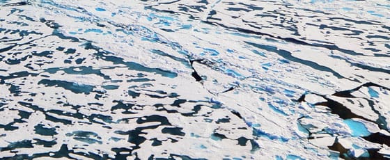
The further North we flew the more floating ice appeared, and finally the amount of open water between the ice shields became smaller than the amount of ice. The entire surface of the ice was covered by melt ponds, some gray and some Florida-pool-blue colored, with occasional seal holes (but no seals, unfortunately) visible in some of the ponds from our 500-ft altitude. Even at 76ºN about 40-50% of the ice, by a rough estimate, was covered by melt ponds. The air temperature was 6 to 10ºC at 500 feet above the ice, and slight fog was clearly visible, lifting off the ocean and the larger melt ponds. Truly, the summer has come to the Arctic.
Turning back South at 82ºN and limited only by the fuel reserve, for the rest of the flight the Gulfstream flew a pattern of ascents and descents between 500 and 28,000 feet, reaching 45,000 on the last flight segment. This part of the flight entered the stratosphere. The high latitudes is the place where this can be done with the Gulfstream, for at the lower latitudes the tropopause (the boundary between the lower, turbulent and fairly well mixed troposphere and the fairly stable stratosphere) is way too high to be reached by aircraft other than highly specialized ER-2 or WB-57. The region between the troposphere and stratosphere is very important for understanding the lifecycle of many greenhouse and ozone destroying gases, and crossing the stratospheric filaments and the tropopause always makes the scientists happy.

We flew past Mount Denali, whose upper third was proudly towering over the clouds and the base was not visible (which is very typical; unfortunately, most people get to see the bottom part of this picture, observing the mountain from the ground), and landed in Anchorage after an 8.5 hour flight and a 12-hour-total working day for the people on board.
This is our last day on the project. Tomorrow morning we will take off on the last flight of this amazing adventure and head back to Colorado.
But don’t despair: in only five weeks this crew will be up in the air again for the Fifth, and the last, part of the Global projects. Come back and the author may humbly offer more articles on the places we have been and the things we were so fortunate to see.